Official Project Title:
Impact Assessment of Projected and Alternative Land Use Development Patterns in Pennypack Creek Watershed
This study assessed the hydrological impacts of alternate land use development patterns at a watershed level. The study was based on Pennypack Creek Watershed (PCW), located in the Delaware Estuary coastal zone, southeastern Pennsylvania. Over the years, PCW has undergone major development and urbanization. The pattern of growth has resulted in the densest development being located in the upper and lower thirds of the watershed, with riparian areas along much of the lower and central main stem and portions of the northwestern headwaters preserved as parks and preserves. In the PCW, the conversion of land cover to less permeable surfaces has increased volume and frequency of runoff and led to a number of problems, including increased incidence of flooding, impaired water quality, and ecological degradation.
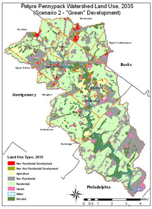
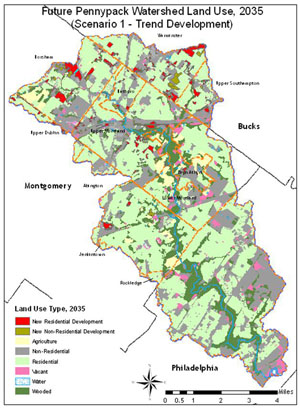
Future land use decisions will significantly impact stormwater and flooding issues in the watershed. This study analyzed the potential impacts of projected land use changes on stormwater runoff and water quality. Specifically, this study compared the effects of two projected future land use scenarios in the PCW. The projected “trend” scenario considered the continuation of current land use practices throughout the watershed. The alternate scenario is a “green” scenario, incorporating a wide variety of sustainable planning and development practices.
The study was undertaken by the Center for Sustainable Communities (CSC) at Temple University. ArcGIS version 10 served as the primary platform for data collection and analysis. The project team started with an examination of the demand for land from projected population growth. The team acquired the most recent official population forecasts from Delaware Valley Regional Planning Commission (DVRPC). Once the population growth within the watershed was projected for each municipality, the associated housing units needed to meet the growth was determined.
GIS was used to build a land suitability model for each scenario. The trend scenario was modeled assuming that future development will be developed at the current housing densities and current development trend. In the green scenario, municipalities accommodated their forecasted population growth needs, but did so by allocating the residential portion of that population growth at significantly higher gross residential housing unit densities. This scenario followed sustainable development principles. The project team ran a survey with participating municipalities to identify suitable lands for future development.
After the land use patterns for both scenarios were determined, the hydrologic impacts of each scenario were assessed. Watershed Modeling System (WMS) 7.1 and HEC-GeoRAS software were used to build a hydraulic model of the watershed. The model showed that in general peak discharge rates, runoff volumes, impervious surfaces, and curve numbers will increase in the trend scenario and decrease in the green scenario. Results were shared with municipalities and relevant professionals. We conclude this report with an argument for watershed-wide multi-municipal planning approach for future developments and stormwater management in this watershed. The study methodology is applicable in other similar watersheds.